


VIKAS SHARMA
JAMMU, AUG 31: As torrential rains wreak havoc across Jammu and Kashmir, the Geological Survey of India (GSI) has identified significant portions of J&K and Ladakh as being highly vulnerable to landslides under its National Landslide Susceptibility Mapping (NLSM) programme, raising alarm over the safety of lives, infrastructure, and fragile ecosystems in the Himalayan region.
According to details presented in the Parliament, nearly 65 percent of J&K’s hilly terrain falls under the low-risk category, while 23 percent has been classified as moderate-risk and 12 percent as high-risk. In Ladakh, however, the scenario is more worrying, with 42 percent marked as low-risk, 37 percent as moderate-risk, and 21 percent as high-risk zones.
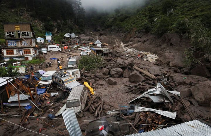
The findings assume critical importance as the region has witnessed repeated disasters in recent years—cloudbursts, flash floods, and slope failures—causing extensive damage. Experts warn that districts such as Ramban, Doda, Reasi, Poonch, Rajouri, and parts of the Kashmir Valley remain particularly vulnerable due to ongoing road-widening projects, hydro-power construction, and unregulated development, compounded by climate-change-induced extreme rainfall.
Union Minister of State for Science and Technology, Dr. Jitendra Singh, in a written reply in the Lok Sabha, informed that the GSI has completed landslide mapping on a scale of 1:50,000 across 4.3 lakh sq. km of hilly and mountainous regions in the country. These maps, categorizing areas into high, moderate, and low susceptibility zones, are vital tools for regional land-use planning and disaster preparedness.
To enhance forecasting, GSI in collaboration with the Indian Meteorological Department (IMD), ISRO, and State Disaster Management Authorities has developed a Regional Landslide Forecasting System (RLFS). Since 2025, the agency has been issuing experimental and operational bulletins for 21 districts across Himachal Pradesh, Uttarakhand, Nagaland, Sikkim, Tamil Nadu, Kerala, Karnataka, and West Bengal. J&K and Ladakh are expected to be brought under this system in upcoming phases.
In the last five years, GSI has also undertaken 45 detailed site-specific investigations of chronic landslide-prone areas across India, several of them in J&K’s Chenab Valley. These studies provide critical recommendations such as slope stabilization, drainage correction, and enforcement of zoning regulations.
The Central Government is further supporting vulnerable regions through the National Landslide Risk Mitigation Programme and the Aapda Mitra scheme, which trains local volunteers in disaster response and rescue operations.
Officials believe the new mapping and forecasting measures will help local authorities ensure safer road networks, hydro-power projects, and housing construction in J&K and Ladakh. However, experts caution that unless stricter land-use enforcement and community-level preparedness are prioritized, the Himalayan terrain will continue to face recurring disasters.